Sunday, June 10, 2018

Great Sand Dunes National Park

Visited: May 2017
Nearby town: Alamosa, CO

"Their appearance was exactly that of the sea in a storm, except as to color, not the least sign of vegetation existing thereon."
-explorer Zebulon Pike, upon his first glimpse of the dunes in 1807

In a remote area of south-central Colorado lies one of the more unexpected sights in nature. A large collection of barren sand dunes lies at the base of incredibly high snow-capped mountains. The contrast created by the sand and the snow make for an awe inspiring vista.

The Great Sand Dunes of Colorado are the largest and tallest sand dunes in all of North America. The tallest dune in the park, Star Dune, is over 750 ft tall. The dunes lie in the arid plains of the San Luis Valley, wedged between the Sangre de Cristo Mountains on the east and the San Juan Mountains to the west. The creation of the dunes is a story of wind and water. The San Luis Valley used to be covered by a lake that disappeared millennia ago, leaving copious amounts of sand that once lied on the lake bed. There are still a number of seasonal lakes and rivers in the valley that evaporate in the warm months, also leaving a lot of sand exposed to the elements. The harsh winds pick up the sand and deposit it at the base of the impassable mountains.


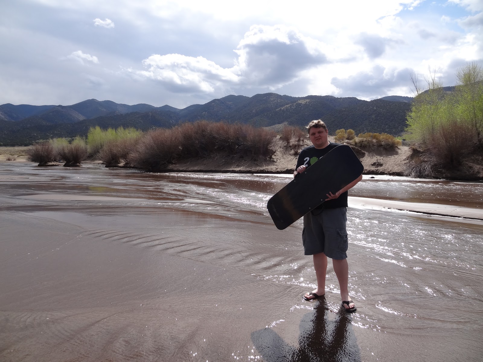
There are a few trails that head up to the forested slopes of the Sangre de Cristo Mountains. But the dunes are of course the highlight and main attraction of the Park. Right before the Park entrance is a store where you can rent sand boards and sand sleds for the day. They'll give you a brief rundown on how to use them, and then you can play and slide down the dunes to your heart's content. Tara got in some good slides...I couldn't quite get the hang of it. 😊


Tara at the top...

Tara at the bottom.


after another somewhat failed attempt 😖


surf's up!

It's pretty tough trudging through the dunes. So when hiking up the dunes, stay on the ridges. Also make sure you're wearing some good footwear especially in the summer months, the dunes can get very hot! 

Another highlight of the Park is Medano Creek, which flows March - May. The river usually dries up completely by late May/early June. It's a very shallow river that runs along the dunes. It's a great way to cool off after sledding for a few hours. Wading in the river was a delight, you can also float down in a tube if the current is strong.


Great Sand Dunes is an easy park to explore in a day, but it is very remote. The scenery is very enchanting. If you want to spend more time in the dunes and the mountains, there is a campground. For more info: https://www.nps.gov/grsa/index.htm

Sunday, June 3, 2018

Black Canyon of the Gunnison National Park

Visited: May 2017
Nearby city: Montrose, CO

"Several canyons of the American West are longer and some are deeper, but none combines the depth, sheerness, narrowness, darkness, and dread of the Black Canyon."
-author Duane Vandenbusche

As the Gunnison River runs it way through central and southwestern Colorado, it cuts a very narrow and steep canyon whose walls are usually shrouded in shadow, the aptly named Black Canyon. Although not the largest or deepest canyon in the country, Black Canyon's steep walls are so jarring and dramatic, the views rivals those of even the Grand Canyon.

At its narrowest point, the canyon is only 40 ft wide at the river. The Gunnison River rips through the canyon, dropping an average of 96 feet per mile in the Park, making for incredible rapids that only an expert should handle.

Most visitors go to the South Rim. It's close to the outdoor adventure town of Montrose, it's much more developed and is accessed by a paved road, contains the visitor center, and most of the overlooks, viewpoints, and trails that descend into the canyon. The North Rim is much more remote (it's an 80+ mile drive from the South Rim) and is only accessed by an unpaved, gravel road.

We visited the South Rim. You can pretty much see all the main attractions in half a day. Black Canyon is a great Park for a day trip. If you want to spend more time, there is lots of campground sites on either rim or at the riverbank (accessed by East Portal Road on the South Rim). If you want to hike down into the canyon you need to get a permit. It's free, but bear in mind the trails that lead down to the river are extremely precarious and not maintained. You can also drive down to the canyon floor at East Portal (on the eastern edge of the park), but the road is closed in winter and is very steep and narrow.

Check out the Visitor Center right at the South Rim Entrance. Then we headed to Pulpit Rock overlook, and got our first glimpse of the canyon.


At the end of the South Rim Road is the trailhead to Warner Point. It's a 1.5 mile roundtrip. Enjoy the views of the faraway San Juan Mountains to the south and Warner Point is an outstanding view of the Black Canyon.


The views at Warner Point:


Some of the most dramatic views of the canyon are found at the Painted Wall. You have lots of overlooks to choose from along the South Rim Road, such as Dragon Point, Cedar Point, Painted Wall View, and Chasm View.


Juniper Tree


The Painted Wall, at 2,250 ft, is the tallest sheer cliff in the state of Colorado. It would dwarf Willis (or Sears) Tower in Chicago, the tallest building in the country. The stripes of lighter covered rock in the cliff face make for an outstanding view.


The Black Canyon is a great place to get away from the crowds and contemplate the beauty of nature without hardly venturing from your car. It's a great day trip, but make sure to get out of the car and stretch your legs on one of the short hikes and enjoy the overlooks. For more info, check out: https://www.nps.gov/blca/index.htm