Wednesday, August 28, 2019

Bear Paw National Battlefield

Visited: May 2016
Nearby town: Chinook, MT

"I am tired of fighting. Our chiefs are killed. Looking Glass is dead. Toohoolhoolzote is dead. The old men are all dead. It is the young men who say 'Yes' or 'No' He who led the young men is dead. It is cold, and we have no blankets. The little children are freezing to death. My people, some of them, have run away to the hills, and have no blankets, no food. No one knows where they are - perhaps freezing to death. I want to have time to look for my children, and see how many of them I can find. Maybe I shall find them among the dead. Hear me, my chiefs! I am tired. My heart is sick and sad.

From where the sun now stands I will fight no more forever."

-Chief Joseph, surrendering his rifle to Col. Nelson Miles on October 5, 1877

On the lonely windswept plains of north-central Montana, just north of the stunning Bear Paw Mountains, is the site of the last battle of the Nez Perce War. It was here that Chief Joseph, after suffering heavy losses after a seige, and at the end of a fighting retreat of 1,170 miles, that the Nez Perce surrendered to the U.S. Army, a mere forty miles from freedom.

In the last blogpost, I detailed our visit of Big Hole Battlefield, and the background and story of the Nez Perce War. Instead of repeating that history, here is the link to that post: https://paulnationalparks.blogspot.com/2019/08/big-hole-national-battlefield.html 

Once the Nez Perce managed to escape the Big Hole Basin, after the bloody battle there, the Nez Perce headed east across the Continental Divide, back into Idaho, and eventually into Yellowstone National Park. At that time, the National Park was only about 5 years old. During their journey east, Gen. Howard continued to pursue the Nez Perce, and skirmishes broke out at Birch Creek and Camas Meadows. The Nez Perce had hostile encounters as well with tourists and prospectors in Yellowstone Park boundaries.

Finally, the Nez Perce came in contact with the Crow Tribe east of Yellowstone. Chief Joseph and the Nez Perce were hoping that they would find refuge with and ally with the Crow against the U.S. Army. The Crow, facing pressure from the army and not wishing to destroy their relationship with the US, had no interest in assisting the Nez Perce and rebuffed their request.

Chief Joseph made a quick decision. The band would turn north and head for Canada. There they would team up with Sitting Bull and the Lakota. Sitting Bull had fled to Canada in the aftermath of the US defeat at the Battle of Little Bighorn (Custer's Last Stand) the year prior and had found asylum there.

The plight of the Nez Perce had generated sympathy for them among whites, even among some members of the US Army, but head General William Tecumseh Sherman was determined to not allow the Nez Perce to reach Canada and form an alliance with Sitting Bull and the Lakota. Sherman was also determined to severely punish the Nez Perce and make an example of them, lest any other tribes might be inspired to rebellion.

Thus, General Howard called on Col. Nelson Miles, stationed at Ft. Keogh along the Yellowstone River, to lead a company of men to the northwest and intercept the Nez Perce, blocking them from entering Canada.

The Nez Perce were badly in need of supplies as they headed north, and as winter approached, were in bad shape. They rushed toward Canada as fast as they could, but a minor skirmish with 50 soldiers and civilian volunteers at Cow Island Landing (a common steamboat stop on the Missouri River) slowed them down. The Nez Perce killed 5 men and were able to get a bounty of much-needed supplies and food. However, the battle slowed them down for nearly two days, and allowed Col. Miles to catch up to the fleeing band.

On Sept 29, an early snow halted the Nez Perce at Snake Creek, just north of the Bear Paw Mountains and only 42 miles from the Canadian border. The Nez Perce camped there to wait out the snow. The Nez Perce were unaware of Col. Miles's approach. Although there were reports of a large number of men to their east, Looking Glass assumed that the men must be other Indians and the band decided to stay at Snake Creek.

It was a fateful decision, because the reported men were indeed the company of Col. Miles. On Sept 30, the Army attacked the Nez Perce on their north flank. The battle had begun. Col. Miles was able to drive off many of the Nez Perce horses, however, the Nez Perce were able to stage an effective counterattack. At the end of the day, the US Army had suffered 18 dead and 48 wounded. The Nez Perce lost 22 men. Col. Miles later commented that "the fight was the most fierce of any Indian engagement I had ever been in ... the whole Nez Perce movement is unequalled in the history of Indian Warfare."
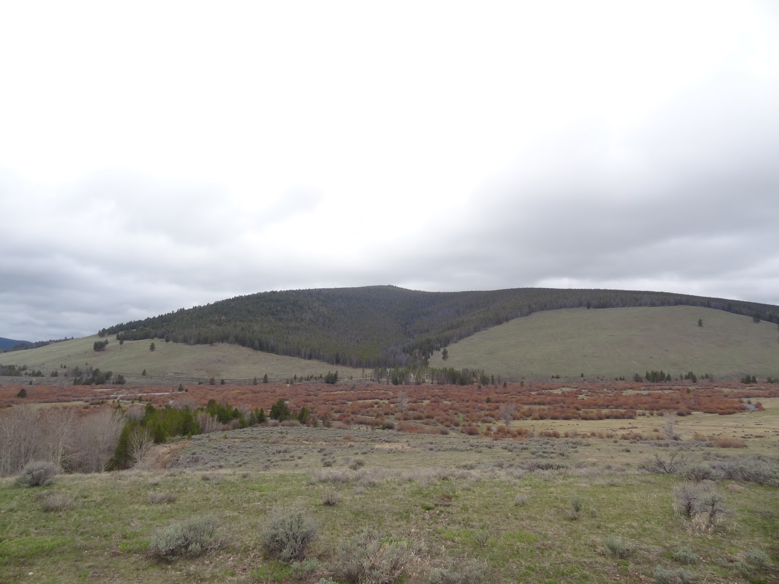
the battlefield


The night of Sept 30 brought another heavy snowfall, allowing both the US Army and Nez Perce to fortify their positions. The US Army was reluctant to attack the Nez Perce fortification, because it was so well defended. However, there was no way the Nez Perce could move from their position, and the Army was much better supplied than the Nez Perce. The Army could simply lay siege and hold out longer. What's more, General Howard arrived at the battlefield on October 4, providing much needed supplies and reinforcements for the Army.

The Nez Perce were divided on what to do, many of its leaders had died in the battle. Only Chief Joseph and White Bird were left. Joseph was leaning toward surrender, he later remarked "We could have escaped Bear Paw Mountain if we left our wounded, old women, and children behind. We were unwilling to do this." White Bird was adamantly against surrender and wished to try to get to Canada.

On the morning of October 5, Gen. Howard had two old Nez Perce recruits accompanying his army approach the band and negotiate terms of surrender. Howard (through the recruits) promised that the Nez Perce would not be executed, they would be given blankets and food, and would be taken back to the smaller 1869 Reservation in Lapwai, Idaho. With those promises, Chief Joseph agreed to surrender, with White Bird apparently conceding to surrender as well.

However, before the surrender was official, White Bird and some 50 followers were able to slip through enemy lines and escape to Canada, hoping to join with other Nez Perce who had escaped during the battle and fled north as well. Some of the escaping Nez Perce were captured or killed, but about 100, including White Bird, did eventually make it to Canada and lived the remainder of their lives in Pincher Creek, Alberta.

Chief Joseph and the remaining Nez Perce officially surrendered on Oct 5, 1877 at 2:20 pm. He handed his rifle to Col. Miles and gave his famous "I will fight no more forever" speech. In total, the number of Nez Perce who surrendered (or were captured) was 431: 79 men, 178 women, and 174 children.

The Bear Paw Battlefield is preserved and managed as a unit of the larger Nez Perce National Historical Park. It's a few miles south of the small town of Chinook, MT. There is a short trail and a number of informational signs, detailing and describing the battle.
Plaque memorializing the surrender. See the next picture for close-up


these rocks allegedly mark the exact spot where Chief Joseph surrendered his rifle to Col. Miles and delivered his famous "I will fight no more forever" speech


As one final injustice, General William Tecumseh Sherman overruled the promises made by Howard and Miles to Chief Joseph as terms of surrender. The Nez Perce were not returned to Lapwai, but instead were sent to the military installation of Fort Leavenworth, Kansas. The living conditions of the Nez Perce at Fort Leavenworth were dismal. Finally, in 1885, nearly 8 years after their surrender, the Nez Perce were allowed to return to the Pacific Northwest, but not to the Lapwai Reservation with the rest of the Nez Perce. Chief Joseph's band were instead sent to live on the Colville Indian Reservation, in northeastern Washington. Chief Joseph died in 1904, at the age of 64, still in exile and never having been allowed to return to see his homeland in the Wallowa River Valley.

For more info: https://www.nps.gov/nepe/planyourvisit/visit-bear-paw-battlefield.htm

Saturday, August 24, 2019

Big Hole National Battlefield

Visited: May 2016
Nearby town: Dillon, MT

"On our part, the war was in its origin and motive nothing short of a gigantic blunder and a crime."
1877 New York Times editorial

The story of the Nez Perce War is certainly one of the most tragic and unjust events in the history of the United States. Because of that, it is not a history that should be ignored, downplayed, or swept under the rug. Indeed, it must be studied, analyzed and confronted if we are to learn from our mistakes.

With that said, the Nez Perce National Historical Park is a unique NPS unit that covers 38 sites in 4 states (Oregon, Idaho, Washington, and Montana). Although the NPS manages the unit overall, some of the individual sites are maintained by other federal and state agencies, and the National Forest Service maintains the Nez Perce Historical Trail. The Park is headquartered in Spalding, Idaho, a small town outside of Lewiston, in the northern panhandle of the state.

Some of the most visited sites of the Park are:
(1) Bear Paw Battlefield - Montana
(2) Battle of the Clearwater - Idaho
(3) Battle of White Bird Canyon - Idaho
(4) Camas Meadows Battle Sites - Idaho
(5) Joseph Canyon - Oregon/Washington
(6) Old Chief Joseph Gravesite - Oregon
and the site that is featured in today's blog post: (7) Big Hole National Battlefield in southwestern Montana.


For centuries, the Nez Perce Tribe lived in the pristine wilderness of the Pacific Northwest - in present day Idaho, Washington, and Oregon. Most of the population was centered in the beautiful Wallowa River Valley in northeastern Oregon. By the 18th century, both Russia and Great Britain claimed this land and conducted fur trapping and other activity in the region, but no permanent settlements were made in the inland regions where many of the tribes lived. Lewis & Clark explored this area for America on their great expedition to the Pacific Ocean. In 1848, the US and the UK settled disputed claims in the region, and the ancestral homelands of the Nez Perce became part of the United States, in the newly-formed Oregon Territory. Tales of the bountiful resources and plentiful, available land brought many settlers to the region, traveling via the Oregon Trail. Inevitably, there were encounters between white settlers and Indian Tribes. Sometimes peaceful, and sometimes not.

In 1855, the Walla Walla Council was held between the federal government and many tribes in the Pacific Northwest concerning resolutions to conflicts over land and the matter of reservations. The Nez Perce Treaty of 1855 was signed at that council. The 1855 Treaty stipulated that the Nez Perce reservation would largely consist of the Nez Perce ancestral homeland in Oregon, Idaho and Washington, consisting of over 7.5 million acres. In exchange, the Nez Perce would cede nearly 5.5 million acres of their traditional lands to the federal government for a nominal sum, with the caveat that the Nez Perce would be able to hunt, fish, and pasture their horses on the unoccupied areas of their former lands (the 5.5 million acres they were giving to the federal government). Furthermore, under the terms of the treaty, no whites settlers were allowed to live on the reservation without Nez Perce permission.

Well, wouldn't you know it, in 1860 gold was discovered on the reservation, near the present day town of Pierce, Idaho. Almost immediately, white settlers descended on the land to mine for gold without Nez Perce permission, in direct violation of the terms of the 1855 Treaty. The town of Lewiston, Idaho was founded on the reservation as a supply depot for the miners; this settlement was illegal. By the late 1860s, nearly 15,000 white settlers were living on the reservation without permission. And the federal government essentially refused to do anything about it and did not enforce the 1855 Treaty. Ranchers and farmers followed the miners, and the farming of the Camas Prairies disturbed the Nez Perce way of life, and tensions escalated between the Nez Perce and the squatters.

In 1869, a group of Nez Perce (who had largely converted to Christianity) entered into a treaty with the U.S. and signed away nearly 90% of the reservation, agreeing to move to a new, smaller reservation of about 750,000 acres east of Lewiston, in land entirely contained in the recently formed Territory of Idaho. Many Nez Perce considered the treaty invalid, because not all bands of the tribe had signed nor participated in the negotiations. Many Nez Perce refused to move to the newer, smaller reservation and remained in the lands of the 1855 Treaty. These bands became to be known as "non-treaty" Nez Perce. One of these "non-treaty" bands lived in the Wallowa Valley in Oregon, led by Chief Joseph.

After the 1869 Treaty, white settlers continued to pour into the region and conflicts and disputes escalated enormously. Murders of Nez Perce by white settlers would go unpunished and unprosecuted. Some of the tribes responded in kind and attacked settlers. Chief Joseph hoped to solve the conflict peacefully, and visited with federal officials in 1873 to attempt to negotiate a peace wherein the Nez Perce would remain on their land and not need to move to the smaller reservation. These negotiations failed, and the atrocities continued. In May 1877, U.S. General Oliver Otis Howard ordered that all non-treaty Nez Perce must move to the smaller reservation within 30 days or they would be moved by force, a nearly impossible deadline. The head Chief of the Nez Perce, Toohoolhoolzote, was jailed after publicly instructing the Nez Perce not to obey the order. Chief Joseph was very conflicted about what to do. He ultimately decided that armed resistance would be futile, and agreed to report to the reservation at Fort Lapwai, Idaho on June 14, 1877.

As the deadline approached, nearly 600 Nez Perce from Joseph's band and a band led by Chief Looking Glass had gathered at Camas Prairie (near the present day town of Grangeville) to prepare to move onto the reservation. On that fateful "last night" of freedom, a group of Nez Perce Warriors talked to each other about the unjust murders of their relatives at the hands of the white settlers (one had a brother killed the previous year who had been falsely accused of stealing horses) and they decided to take matters into their own hands, and exact vengeance. A group of Nez Perce Warriors raided a settlement along the Salmon River on the night of June 14, killing four white men.  The following night, some Warriors raided more settlements. In total, 18 settlers were killed. Chief Joseph had hoped to still negotiate a peace when reporting to Fort Lapwai, but at this point knew that it would be to no avail on account of the raids.

In response to the raids, Gen. Howard sent 130 men under the command of Captain David Perry to punish the Nez Perce and forcibly move them to the reservation. This unit met about 70 Nez Perce Warriors in White Bird Canyon just south of Grangeville. Six Nez Perce warriors approached the army with a white flag, hoping for a truce. For reasons never totally explained, the army fired on the truce party. The party quickly took cover and fired back. The Nez Perce War had begun. The army suffered a humiliating defeat by the Nez Perce, who were much more experienced at fighting on horseback and were much more familiar with the land. Captain Perry's men were forced to retreat. At the conclusion of the White Bird Battle, nearly 34 U.S. soldiers had been killed, none of the Nez Perce had fallen in the battle, and only 3 were wounded.

Despite the resounding victory, Chief Joseph knew that the U.S. Army's retaliation would be swift and brutal. The Nez Perce would be overwhelmingly out-gunned and out-numbered. Joseph knew there would be no way they would survive a full-scale war. Chief Joseph decided to lead his band on a fighting retreat. They would head east and seek refuge and team up with the Crow Tribe in southeastern Montana. The band totaled approximately 250 Nez Perce Warriors, 500 women and children, along with 2,000 horses. They headed out across Lolo Pass into Montana, doggedly pursued by a large regiment under Gen. Howard, the Nez Perce fought them off and retreated successfully at small skirmishes at Cottonwood, Clearwater, and Fort Fizzle outside of present-day Missoula.

After Fort Fizzle, the retreating band headed south through the Bitterroot Valley. Chief Looking Glass pledged to the white settlers in the valley that they would pass through without violence. They did so, and the Montana settlers, not eager for war with a tribe that had successfully fought off the U.S. Army, even traded and exchanged goods with the tribe as they passed through. Once the band left Idaho Territory, Gen. Howard's men had eased off on their pursuit of the Nez Perce. This let the Nez Perce travel at a more leisurely pace and they decided to rest in the Big Hole Basin, just south of the Bitterroot Valley, to rest and recuperate. They set up 89 tipis in a V-shaped pattern along the North Fork of the Big Hole River. 

Big Hole River

The Nez Perce camped at the foot of this mountain in the Big Hole Basin

Unknown to the Nez Perce however, Colonel John Gibbon had left Fort Shaw (just outside of present-day Great Falls, Montana) with 161 men and a howitzer and was pursuing the Nez Perce through the Bitterroot Valley. His orders: no prisoners and no negotiations. His army was able to recruit some citizen volunteers in the Bitterroot Valley, and his unit ended up reaching a little over 200 men.

On Aug 8, 1877, Col. Gibbon located the Nez Perce encampment at Big Hole. They set up camp, hiding in the trees on the mountain overlooking the camp. In the wee hours of the morning of Aug 9, the army descended on the tipis. They encountered an old Nez Perce man as they were crossing the river, and shot him immediately. They then fired indiscriminately towards the tipis, killing many - including women and children. The Nez Perce, taken completely by surprise, scattered in every direction. Instead of pursuing the fleeing band, Gibbon ordered his men to burn the tipis. This brief pause in the battle, allowed the Nez Perce warriors to rally and fight back. Gibbon's men began to suffer many casualties and retreated back across the river and into the forested mountain were they dug trenches and fortified their camp. The Nez Perce were able to capture the howitzer and dismantle it. The remaining day of the battle consisted of the army and the Nez Perce sniping at each other. The Nez Perce were able to hold off the army with their snipers as they prepared to retreat. Meanwhile, Gibbon had run out of supplies, the only food being their dead horses. Many of the civilian recruits had abandoned the army and slipped away. Gibbon, believing he was seriously outnumbered (he probably wasn't) sent a message to Gen. Howard's men (who were still about 80 miles away) and requested immediate relief. On Aug 10, a couple dozen Nez Perce sharpshooters were able to hole up Gibbon's men (who had no food or water) in their fortifications the entire day, allowing the band to slip away and escape further to the east.

The battle was costly for both sides, Gibbon had lost 31 men and 38 more had been wounded. The Nez Perce lost about 70-90 people, about 30 of which were warriors and the rest women or children. Big Hole ended up being the deadliest battle of the Nez Perce War. When they had left Idaho, Chief Joseph had hoped that maybe the army would give up its pursuit and they could live peacefully in Montana. But at this point, Chief Joseph knew beyond any doubt that such a conclusion would be impossible. His band pressed on to the east, hoping to unite with the Crow Tribe. Their story will continue in my next blog post about Bear Paw Battlefield.

Visiting the battlefield is a sad, but special, experience. The Visitor Center is very good and has all the information on the battle, and you can take two trails. One follows the river to the Indian encampment. As a memorial, the park has set up 89 tipis (just the poles) in the approximate spot of the camp. The other trail leads up the hill overlooking the valley, where the US Army camped during the battle.


overlooking the Big Hole River

overlooking the battlefield, you can see the tipis in the distance


this monument was erected by US army in 1883

Today, the NPS preserve this battlefield and honors all those who lost their life here in this tragic incident. This somber site is a must visit for anyone who wishes to understand more about our history and heritage. More info here: https://www.nps.gov/biho/index.htm

Tuesday, August 13, 2019

Voyageurs National Park

Visited: Aug 2018
Nearby town: International Falls, MN

"I could carry, paddle, walk, and sing with any man I ever saw. I have been twenty-four years a canoe man, and forty-one years in service; no portage was ever too long for me, fifty songs could I sing. I have saved the lives of ten voyageurs, have had twelve wives and six running dogs. I spent all my money in pleasure. Were I young again, I would spend my life the same way over. There is no life so happy as a voyageur's life!"
-an anonymous retired voyageur, quoted in the book "Lake Superior" by James H. Baker, Secretary of State of Minnesota 1860-1862

In the far reaches of Minnesota, along the border with Canada, Voyageurs National Park protects the pristine wilderness of the Kabetogama Peninsula and its surrounding lakes; Rainy Lake, Kabetogama Lake, and Namakan Lake. 

From the 1680s all the way to about the 1870s or so, this area was a prime hub of the fur trade industry. Voyageurs (French for "travelers") were French Canadians - mostly from the Montreal area - who would be hired by wealthy merchants to travel by large canoes up the St. Lawrence River all the way to the western edge of Lake Superior. There, at Grand Portage, they would take smaller canoes and venture into the wilderness to trap and trade with Native Americans for pelts and fur of a variety of animals: marten, otter, lynx, mink, and especially beaver. They would then transport the furs all the way back to Montreal for export across the ocean to Europe. They would repeat this process throughout the year until the wintry weather made the journey impossible. As hats made from beaver fur became incredibly popular in the cities on the East Coast and Europe, the business exploded and at its height in the 1810s, there were over 3,000 voyageurs.

The voyageurs were highly valued employees of the prominent fur companies; including the Hudson's Bay Company, the North West Company, and the American Fur Company. Voyageurs would arise daily at around 2 in the morning and begin the long day of paddling. Voyageurs were expected to work 14 hours a day and paddle at a rate of 55 strokes per minute. They would take a short break once an hour to smoke pipe. Distance was measured in "pipes" (distance traversed between breaks). Obviously there was little time to hunt for food, so a voyageurs diet mainly consisted of what they could store in the canoe: packaged meals such as salt pork, rubaboo (a stew made from dried peas or beans), sea biscuits and pemmican (dried meat pounded into small pieces mixed with fat). 

When it came time to carry the canoes and cargo over land (what is known as "portaging"), voyageurs were expected to carry two bales of fur, each weighing 90 lbs. for a total of 180 lbs. Some carried more, to reduce the amount of trips back and forth to portage all the cargo. There is a report of a freed slave that became a voyageur named La Bonga, who was 6 ft 5 in. tall and once carried 7 bales (630 lbs.) for a distance of one-half mile.

This was dangerous work; many voyageurs never learned to swim and drowning was common, as was broken limbs, compressed spines and hernias (due to all the heavy lifting).

Music was an everyday part of life for the voyageurs. The men would sing as they paddled, to help pass the time and improve and boost morale. Furthermore, the rhythm of the songs helped synchronize their paddling. Some of the most popular songs were "Alouette" and "A la claire fontaine." Canadian school children to this day learn voyageurs songs as a part of studying French Canadian culture. The exploits and adventures of the voyageurs are legendary and a large part of Canadian social culture and history. Much like the fabled pioneers in US history.

If there is one thing to do at Voyageurs National Park, I would recommend participating in a North Canoe program. The rangers (in traditional Voyageur garb) will teach you all about their history and then take a group out onto the lake in a replica canoe. The rangers stay in character the whole time, and you'll sing songs, and all that stuff. It's very fun and enjoyable. It's free, but you do need to sign up for it, so call ahead and reserve a spot. It's available at either the Rainy Lake Visitor Center or the Lake Kabetogama Visitor Center. We did ours at Lake Kabetogama.


Lake Kabetogama


The Voyageurs


There are three visitor centers in the park (from east to west): (1) Ash River (2) Lake Kabetogama (think of the Roman "toga" when you pronounce it: Caw-be-toe-gama) and (3) Rainy Lake. These visitors centers lie on the outskirts of the park. Most of the park lies on the Kabetogama peninsula (which can only be accessed by boat) and 40% of the park is water. You can't really explore the park in your car, so to truly experience the park you need to get out on the lakes and rivers with your own boating equipment, or rent some, or go on guided tours.

In the Ash River section of the park, take the Blind Ash Bay Trail for outstanding views of Lake Kabetogama.


Make sure to stop at the Ash River Visitor Center for scenic views and a great picnic stop. The narrows here connect Lake Kabetogama with Namakan Lake.


We also stopped at the Rainy Lake Visitor Center to soak in the views.


saw some turtles on a log basking in the sun
There are a number of guided tours by boat that are available either from Rainy Lake Visitor Center or Lake Kabetogama Visitor Center. We took the Kettle Falls tour from the Lake Kabetogama (you can also do a tour of Kettle Falls from Rainy Lake Visitor Center as well).

Kettle Falls is an area of rapids located in the waterway connecting Lake Kabetogama with Rainy Lake. The falls required voyageurs to portage at this spot. In 1910 a dam was built here. And in 1913, the Kettle Falls Hotel was built here, right on the edge of the Kabetogama Peninsula. This historic hotel still operates today. It is the only lodging inside park boundaries, and is only accessible by boat. The boat from the visitor center is a small pontoon boat (I understand the boat from Rainy Lake is much bigger). Reserve ahead of time to make sure you get a spot on the boat. The small group made for an excellent guided tour and lots of opportunity to view wildlife. The boat ride takes a couple of hours but the rangers make it interesting. Don't worry about motion sickness, these are calm waters. Once you get to Kettle Falls you'll have an hour or so to explore on your own, eat at the hotel's restaurant, see the dam, etc.


bald eagle


Kettle Falls Hotel

hotel patio


the floor of the billiard room was very warped


the rapids of Kettle Falls


We loved our visit to Voyageurs National Park. If you find yourself in Minnesota, head north to experience this natural wonder and learn of its unique history. If you visit, make sure to take a guided tour or bring a boat so you can experience this part from the water as intended. More info here: https://www.nps.gov/voya/index.htm