Saturday, April 24, 2021

Knife River Indian Villages National Historic Site

 
Visited: Aug 2018
Nearby town: Stanton, ND

In central North Dakota, about an hour's-drive northwest of Bismarck, you will find the archaeological remains of three villages of the Hidatsa tribe (a band of Northern Plains Indians). The villages lied along the Knife River, a tributary of the mighty Missouri.

The villages were first established around the year 1600. At its height, experts estimate that approximately over 1,200 people lived in these villages. There are no standing remains, but you can still see the circular depressions in the ground (created by earth-lodges), cache pits, and the trails created by travois. Travois are frame structures that would be dragged (usually by horses, but sometimes by dogs) in order to carry large and heavy loads overland.

The most famous person to have lived in these villages was Sacagawea. Sacagawea was born into the Lemhi Shoshone tribe near the present-day Idaho-Montana border. However, around the year 1800, when she was around 12 years old, she was taken captive by the Hidatsa during a raid, and eventually ended up here. A year later, she was sold into a "marriage" to Toussiant Charbonneau, a fur trader from Quebec. Charbonneau had been living among the Hidatsa for decades. In 1804, the famous Lewis & Clark established Ft. Mandan nearby to spend the winter. They recruited Charbonneau and Sacagawea to join the Corps of Discovery, mainly because Sacagawea could speak Shoshone (the language of many tribes that Lewis & Clark would come across as they continued their journey). Sacagawea's guidance, language abilities, and knowledge of land and tribal customs proved invaluable to the expedition's success.

Your first stop should be the outstanding Visitor Center, which has a very unique and memorable design.


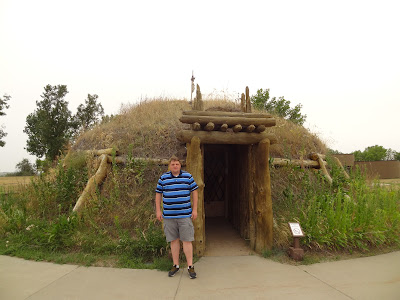
They also have a reconstructed earth-lodge. Most earthlodges were dome structures, with a small smoke-hole at the apex of the roof. Earthlodges were used by the Hidatsa peoples, but also many other tribes (Mandan, Arikara, and Mississippian culture). 


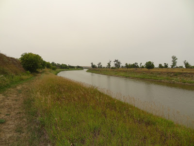
Take the park loop trail. It's only about a mile. See the remains (the circular depressions - or "footprint" of the earthlodges) and walk along the Knife River. It's a pleasant walk. We spotted some deer along the river.


The Knife River Villages were an important trading center in the area. The trade here largely consisted of furs, guns, copper, corn, and other agricultural products. 

The villages thrived until about 1837, when smallpox outbreaks nearly wiped out the entire Hidatsa population. The survivors of the tribes affected by this outbreak (Hidatsa, Mandan, and Arikara) eventually migrated farther north.

This is a interesting stop for an hour or two and is worth visiting if you are in the area. For more info: https://www.nps.gov/knri/index.htm 

Saturday, April 17, 2021

Apostle Islands National Lakeshore


Visited: Aug 2018
Nearby town: Bayfield, WI

The beautiful Apostle Islands are located in Lake Superior, just off Wisconsin's northern coast. There are 21 islands, the largest of which is Madeline Island. Madeline is the only island with commercial development and private ownership of land. The other 20 islands are protected by the National Park Service as Apostle Islands National Lakeshore, established in 1970.

We stayed on the Wisconsin mainland in the town of Bayfield. This is where you can take a ferry to Madeline Island (in the winter the lake freezes over and you can take the "ice road" to the island). Bayfield is also the spot to embark on guided tours of the Apostle Islands. Apostle Island Cruises is the NPS-authorized concessioner and it offers a variety of cruises and/or kayaking to explore the islands. We stayed in Old Rittenhouse Inn in Bayfield, a cozy and picturesque bed & breakfast.

We took the Morning Grand Tour through the Apostle Island Cruises, it was a great trip. This 1/2 day tour cruises along almost all the islands (including Devils Island), and provides great scenery. It does not dock at any of the islands. We got great views of the town as we left the port at Bayfield.


You'll pass by Basswood, Hermit, and Oak Islands. Enjoy the scenery.


Glaciers used to cover this area during the Last Ice Age. As the glaciers melted, the waves of the newly-formed Lake Superior caused the erosion you see on the red sandstone of these islands. The earliest known inhabitants of the islands were the Anishinaabe peoples in around 950 AD. French fur explorers, led by Etienne Brule, first spotted these islands around 1630. Jesuit priests later named the island group after the Twelve Apostles (because it was made primarily up of 12 larger islands).


The highlight of the tour is Devils Island. The boat slowly goes around the whole island. There is a lighthouse, and the craggy coastline is full of sea caves (you can take a specific tour that explores some of these caves by kayak) and incredible natural arches. It reminded me of Arches National Park...if it got flooded. 😀 It was very unique and memorable.


For more info, here is link to NPS site: https://www.nps.gov/apis/index.htm

BONUS: head over to nearby Duluth and explore the spectacular North Shore of Lake Superior along the Minnesota coastline. We stopped at Split Rock Lighthouse, Gooseberry Falls, and the Palisades cliffs. 


the large foghorn at Split Rock Lighthouse


incredible scenery of Split Rock Lighthouse


the tannin of Gooseberry Falls gives the water it's root-beer brown color.


Duluth skyline

the unique Aerial Lift Bridge in Duluth. The lower portion of this bridge raises up for boats to pass under.


We loved our time in this beautiful part of the country.